
TransLink Wayfinding 101: all about maps
TransLink Wayfinding 101: all about maps
![]()

This is part of our ongoing Wayfinding 101 series taking a closer look at wayfinding at TransLink, bringing you the ins and outs, and answers to your questions.
Who needs printed maps when you have Google Maps? We all do! And it’s not just in case the internet goes down. Printed maps help customers create “mental maps” of where transit services are located.
While Google Maps is effective to help you get from point A to point B, it doesn’t tell you much about the broader transit network.
“Maps instill network awareness in our customers,” says Jada Stevens, wayfinding specialist and graphic artist at TransLink. “No matter where they are, we want customers to have a general idea of what services run, how often they run and to what destinations. Our maps work in tandem with tools like Google Maps to get you where you need to go.”
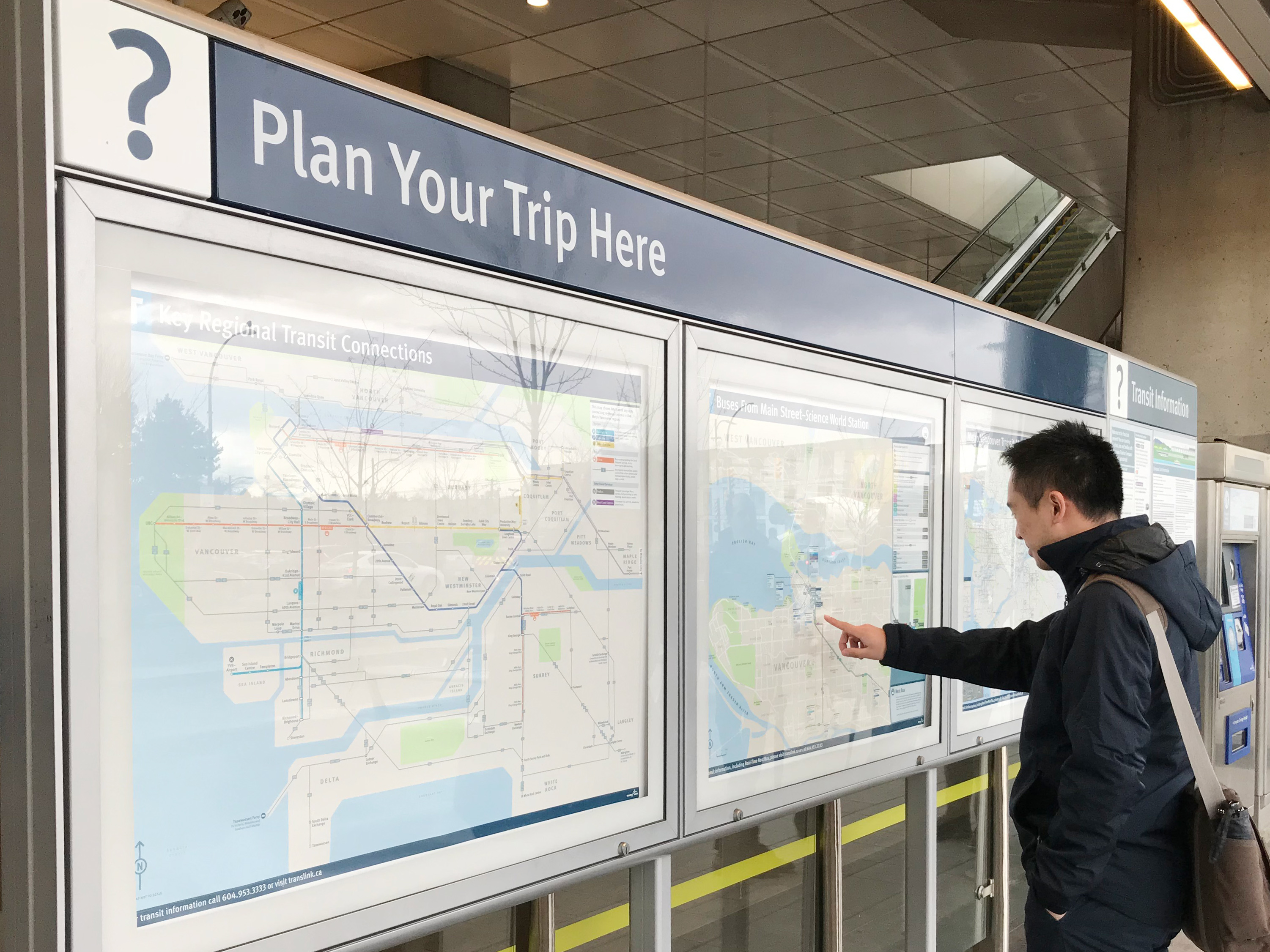
The kind of maps we provide offer solutions to different travel objectives. Is this a simple point A to B trip, or are you connecting from SkyTrain and onward to bus? And does a part of your transit trip involve a walking connection?
No single map can offer all solutions, which is why we provide three different kinds of maps on the system: a complete network map, bus maps from a specific transit location, and walking maps. Additionally, our maps are complimented with diagrams that simplify the network into transit destinations for easy reference.
Here they are! (P.S. you can click each image to see a larger version of each map.)
Maps
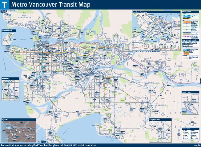
The Metro Vancouver Transit Map displays the complete transit network, showing all transit routes available at all times, along with roads, parks and points of interest. It aids in trip planning, navigation, network awareness, and with estimating distances between destinations. This map is geographically accurate, which means distance or geography isn’t distorted to improve information legibility.
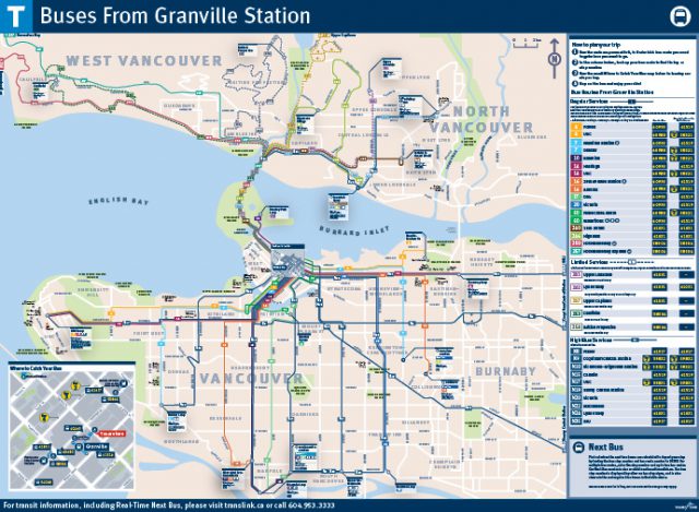
At SkyTrain stations and bus exchanges you will find the “Buses From Here” maps showing bus routes that leave from that specific location and where to catch those buses.
While this map doesn’t show the bus connections beyond that one-bus ride, it’s designed to work in tandem with the Metro Vancouver Transit Map to help customers further plan their trip beyond the first Compass tap.
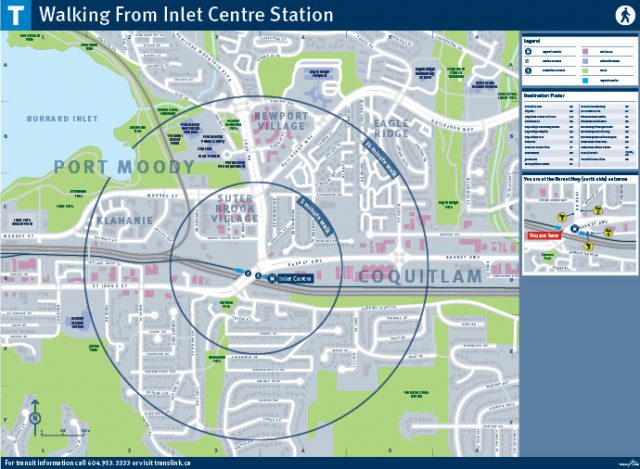
The “Walking From Here” maps share information about the local community within a 5- or 10-minute walk from a SkyTrain station. While no transit information is included on this map, it shows a detailed area view around the station. The view includes popular destinations such as community centres, schools, parks and retail in an effort to help people find their destination by foot.
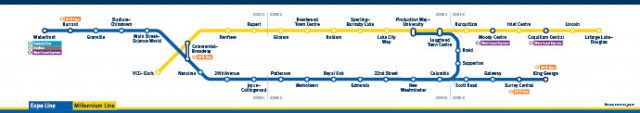
Diagrams
Diagrams are a simplified representation of the SkyTrain network which helps you understand what stops lie ahead in your direction of travel. They do not accurately convey distance or geography, but instead create an easy-to-follow progression of the SkyTrain network to be understood without the complications of unnecessary information.

Hybrids
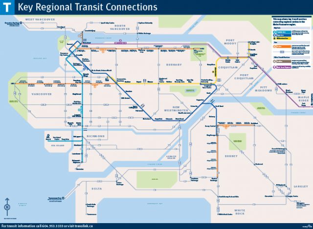
The Key Regional Transit Connections map shows route frequency and network connectivity between urban centres. This is a schematic map, which means it is a combination of a map and a diagram. It isn’t geographically accurate as distances have been skewed, angles are reduced, and information has been simplified, but it provides a great snapshot of our key regional connections.
There you have it!
Maps are a fantastic way for locals and visitors to learn about our region and our transit system. The next time you’re travelling through a SkyTrain system or waiting for a bus at a bus exchange, take some time to check out our maps! At many of our locations, you’ll find unique maps helping to illustrate where you are in the transit system.
If you’re interested in viewing more of our maps, our website is also a great resource!
Thanks Allen. Really like TransLink’s maps – clear and easy to understand.
Is it possible one could purchase copies of these maps, (namely the full Metro Van and Key Regional Transit Connections) for collections? Call me a transit nerd, but I’d enjoy having these grace my walls.
Hey Graham, it’s possible we could one day sell these in the TransLink Store. I’ve passed this on to the right folks at TransLink.
In the Diagrams image, how come Waterfront Station on the Canada Line map is served by a B-Line but the Expo/Millennium Line map is not?
Hi Michael, I checked in with the Wayfinding team. Here’s what they had to say:
Hope this answers your question!
Is there any possibility that used items will be sold through the Translink Store? Not only maps but pieces like the original SkyTrain station signs, which are steadily being replaced by new ones in the latest graphic style.
Hey Ian, I’m told this is being looked into! =)
Thanks for the good news about new items to the TransLink Store!
Why is that when you click on the metro Vancouver transit map, it takes you to an error page? And can somebody fix it please?