This is part of our ongoing Wayfinding 101 series taking a closer look at wayfinding at TransLink, bringing you the ins and outs, and answers to your questions.
This week, we’re going to do something a little different and bring you a guest post from Jada Stevens, wayfinding specialist and graphic artist at TransLink.
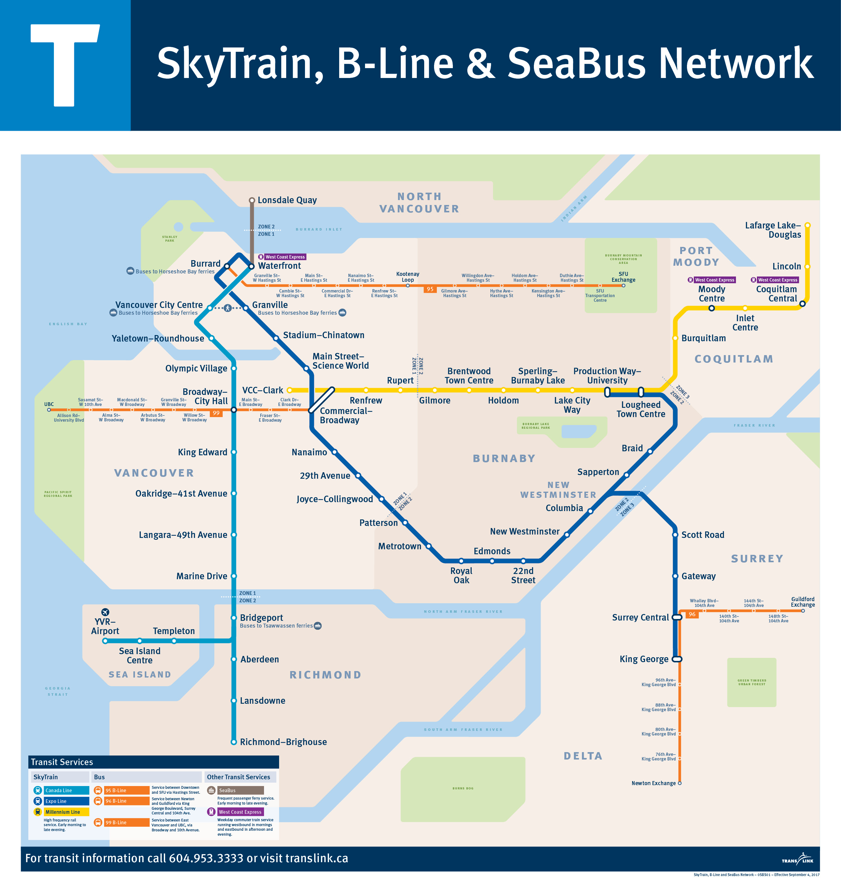
She designs TransLink’s myriad of maps, including the SkyTrain, B-Line and SeaBus Network map that’s found at SkyTrain’s platform level. This map is used as a high-level snapshot of our fastest, most frequent and highest-capacity modes of transit. The routes on this map create the foundation of TransLink’s entire network, and these routes have become synonymous to the growth and liveability of our region.
It’s up against Chile’s Santiago Metro in the World Cup of Transit Maps today, so we’d thought we’d reach out to Jada to write a guest post about all the quirks and details about this map!
By Jada Stevens
Like most transit maps worldwide, the SkyTrain, B-Line and SeaBus Network map is an octolinear diagram composed of only 45 and 90 degree angles. This style of map is not meant to accurately portray distances, but to show the rapid transit network in a series of steps as you travel from one station (or stop) to another.
While landmarks such as roads and points of interest have been left off this map, a sense of location has been achieved by the underlying land base. In circumstances where part of your trip might be in a tunnel, it can be easy to lose your sense of location. That’s why it shows geographic landmarks such as the river crossing between Bridgeport and Marine Drive stations to help with self-location.
Much attention has been paid to informational hierarchy on this map.
The SkyTrain, the fastest and most frequent mode of transit, is the most prominent with the thickest line and largest type size. The B-Line bus network, which is next in frequency and capacity, is slightly less apparent than SkyTrain but all stops are still clearly shown. Finally, tertiary information such as municipalities and park names, while important, is decreased in size or opacity in an effort to not clutter the more important information. It virtually fades into the background and is only visible when searched out.
This map also illustrates the physical fare zone boundaries that exist along the SkyTrain network for new or infrequent transit customers such as visitors. Look for the dotted lines like between Lougheed Town Centre and Burquitlam stations! It also shows which municipalities fall into the same fare zone by using different shades for the land base. For example, Burnaby and Richmond share the same land base shading as they share a fare zone, while Surrey and Vancouver are shown as a different shade.
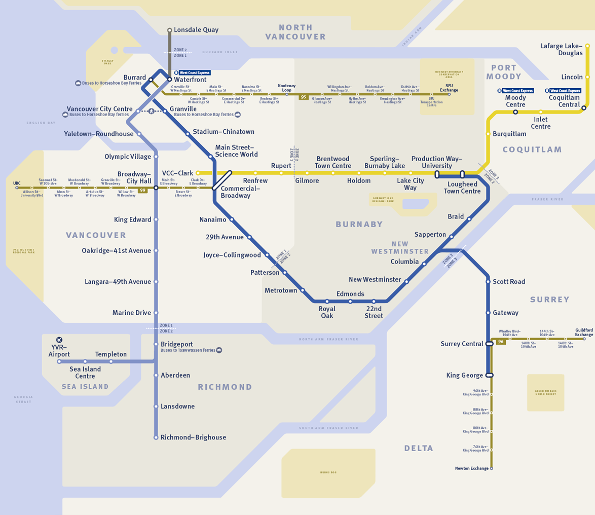
High contrast version of the SkyTrain, B-Line and SeaBus Network map (click to enlarge).
While we’re on the topic of shading, did you know that this map was designed with the explicit intention of being legible to customers who are colourblind? When the map is converted into a preview that reproduces the effects of colourblindness, you can clearly see a contrast between all the modes of transit, fare zones and bodies of water.
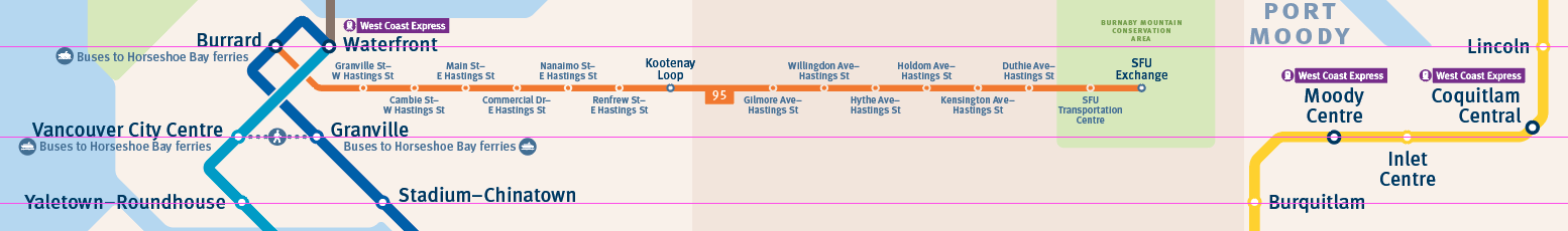
And finally, were you aware that this map was designed on a grid? Wherever possible, every attempt was made to horizontally align station dots to each other across Metro Vancouver. Designing an octolinear map to a grid creates a greater sense of symmetry and balance, which in turn is more pleasing to the eye!
An example of how the map is designed to follow a grid.
Sold on our SkyTrain map? Make sure you vote for it in the Twitter poll below for the World Cup of Transit Maps! It closes Friday, April 20 at 11:59 a.m.
Match 24 of the #wctransitmaps – the last Round of 16 match – is here. RT for more votes!
ROUND OF 16 – BLUE LINE MATCH 6 —-
Which city has the better designed transit map, Vancouver or Santiago?

Sad you guys are losing. It’s a great map and I hope TransLink is up to as part of #ILoveTransit Week holding some classes on Wayfinding please!
Congratulations to my online friends Jada N. Stevens & Phil Kehres on a great map. The best map I’ve ever seen – and I’ve rode a lot of transit systems between Vancouver, BC & McMinnville, OR.
I saw the Santiago map has cross streets as well, which would make it easier to understand where each station is located. Also, I would not say that most transit maps are schematic like this one. As an example, Montreal and Toronto both offer geographic maps that assist you in wayfinding the city. Overall, I miss the old geographically accurate full-size Translink system map that you could buy at places like Safeway for $2 (maybe it is still available but the last one I saw was only 11×17 and I haven’t seen it for a while).