I Love Transit Week 2010: two belated transit treats
I Love Transit Week 2010: two belated transit treats

During I Love Transit Week last week, two readers posted some super fun links that I neglected to put up on the blog!
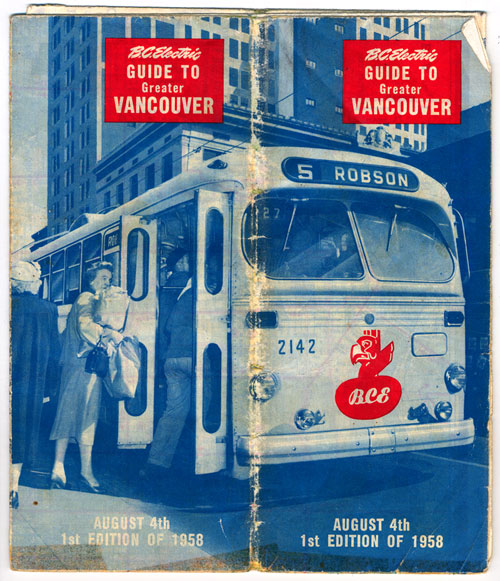
So to make amends, here they are now. The first is from Owen, who posted a Vancouver transit map from 1958! Check out his post for more pictures and hi-res map downloads.

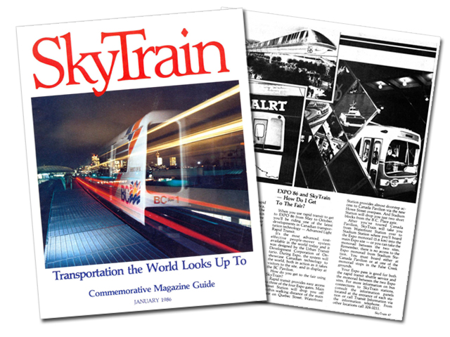
The second is from Jason Vanderhill, who tweeted out scans of SkyTrain magazine, the commemorative magazine issued for the opening of SkyTrain in 1986!
Download the full magazine in two parts:
I must say my favourite parts are the ads, btw :)


[…] This post was mentioned on Twitter by Breaking News in Van, iSkytrain. iSkytrain said: I Love Transit Week 2010: two belated transit treats http://ff.im/-oa4pM […]
I love the 1958 map of the transit system, thanks for sharing. The airport would have been at the south terminal as the main terminal was not opened until 10 years after this map. Some bridges missing. North Burnaby looks like wilderness and Surrey doesn’t even exist (or it’s all farms and has no bus service).
Interesting that West Van is not shown – obviously it was a separate system and not integrated back then.
The more things change, the more they stay the same. The #72 bus on northern Sea Island was subsequently rerouted off Miller onto Grauer (when the #71 was rerouted to the new terminal in 1968), then discontinued in 1976–only to reappear as the C90 over 20 years later! The W1 and W3 look a lot like the 101 and 112, but there were a LOT of intervening changes. And the B10 in North Burnaby is almost today’s C1, except that it was replaced by the 39 Delta to Brentwood Mall, became the 139, was cut back to Hastings & Willingdon, replaced by the 131, drestored, and then became the C1.
As for Surrey, it was served by Pacific Stage Lines (a subsidiary of BC Electric, then BC Hydro) until 1975, when it was integrated with the rest of the transit system. (Ditto for Delta and White Rock.)
The B3 in South Burnaby is another curiosity: it was replaced by the 30 Willingdon (later 130) in the early 60s, only to reappear so many years later as the 116 in 1986.
The other thing to notice about the map is that back then, many routes had different numbers, depending on the direction of travel. To go Downtown from Broadway & Arbutus, you could have taken a 14 Hastings, 16 Renfrew, or 34 Hastings Express back then; but coming back, you’d have to take a 7 Dunbar, 10 Tenth, or 18 Arbutus.
As for Coquitlam, there was Pacific Stage Lines and private operators, but also one BC Electric service: the W1 Fraser Mills, which had started out as a streetcar line in 1912; it eventually became the 154/155 (which used to go into Coquitlam).
And more trivia, if y’all will bear with me:
* The 236 follows the N3 Capilano’s route today, but from later that same year (1958), it became the 88 McKay, was cut back to 22nd & Keith, became the 236 in 1977, then was finally extended back along Capilano Road in 1988.
* Likewise for the 6 Fraser/15 Cambie. The Fraser/Cambie was Vancouver’s first trolleybus route in 1948, but was broken up in 1949, reunited in 1957, broken up again in 1981, and had one last fling as the 8/15 from 2003 to 2005.
* And finally, that map was published only 6 months after the very last interurban tram stopped running: the Marpole-Steveston interurban (which had originally run all the way Downtown via the tracks along Arbutus). It was replaced by the 60 Richmond Express, which was replaced by the 401/403/406 in 1977, and came back as the 98 B-Line–and then, bringing things full circle, rail transit came back in the form of the Canada Line!
sewing: Oh, you know we all love trivia around here. Fascinating!
Jhenifer:
Thanks. I’m working on something germane to this–a database of Metro Vancouver’s transit routes–but it’s still under construction and not publicly available right now. Too late for “I Love Transit Week,” alas.
Or it could be very early for next year’s I Love Transit Week :)
Wow, what a treat, Jason and Owen! Great trivia too, Sewing! Thanks for linking to these Jhenifer!
Have a great weekend, everyone! :)
I didn’t want to advertise my own stuff, but to get this in under the wire, here’s a preview: http://fairviewsfu.blogspot.com/
That’s the first 35-or-so transit routes numbered from 1 to 10 (from 1 Fairview to 10 Granville/Hastings), from 1890 to 2010. It includes New Westminster’s and North Vancouver’s streetcar routes, too, so it’s not all Vancouver-centric.
http://fairviewsfu.blogspot.com/
there’s an error in the SkyTrain Expo86 booklet (.pdf part 2).
The #41 Metrotown Station should read #49 Metrotown Station (towards the end of the page)
George:
Actually, that is not an error! From January to March 1986, the 41 (which had previously routed as the “41 Burnaby South” via Kingsway to Nelson) was rerouted via Willingdon and Central Blvd to Metrotown Station.
Meanwhile, the 49 Burnaby South was still routing via 49th, Imperial, and Nelson to Kingsway. In March of that year, the 41 was diverted to Joyce Station, the 19 was extended from Joyce Loop (on the east side of Joyce south of Kingsway) to Metrotown, and the 49 was rerouted to Metrotown Station.
I rode the 41 out to Metrotown Station one day that winter, and sure enough, there was a lone 130 there–the only other route to serve the station at the time. The whole area north of the loop–where Station Square and Metroopolis are today–were at that time vacant lots, having previously been occupied by huge warehouses. A city boy, I felt like I was way out in the boonies somewhere–and today, Metrotown is practically the centre of the entire region!
(A bunch of other changes happened in March as well, of course, including the 130’s being split up into 2 sections: the 116 Suncrest and 130 Kootenay Loop.)
I much preferred different #s for different directions, back in the day the #9 and #41 and #49 had the same number, but all the others had their own numbers (10/14, 20/25, etc)
To retweet my comments on the ’58 map: Awesome map… 23 Macdonald, old Georgia Viaduct, Chancellor Blvd connects to 8th, not 4th, the Fraser Street Bridge, and no such thing as Great Northern Way, and no 401 Freeway. No 16th Ave to UBC, but there is King Edward. Canada Way is Grandview Highway… North Vancouver Ferry. Take a close look at Queensborough, the Queensborough bridge we know was built in 1960, before that the railway bridge was used by motor vehicles. The “Lulu Island Bridge”, a/k/a Eburne Bridge, is a remnant of the pre Oak Street “Marpole” Bridge which crossed from Marpole to Sea Island and then to Lulu Island before the “Moray” bridge (since twinned) was built.
Is the bike path still sponsored by 7-Eleven? While the path remains, the signage seems to have faded away.
I forgot Molson’s put the jogging trail together.
Wow, great memories of Expo86 :).
Wow, that map kind of proves this theory I had. I always thought Broadway Street in Burnaby and Broadway Street in Vancouver were one and the same because they seemed to line up just right on maps. I could never really confirm it though. (That and I never really gave it much thought).
Looks like I was right. In the map above, one of the Burnaby sections of Broadway is titled as “E. Broadway”. As Vancouver’s address system carries over into Burnaby, no address on Broadway in Burnaby should be the same with any address on Broadway in Vancouver.
;-): The bike path isn’t sponsored by 7-Eleven anymore, as far as I know. Virtually all the 7-11 signage is gone!
sewing:
That’s interesting. So for a short time (between the time Joyce Loop ceased to exist to until the trolley overhaed was completed to Metrotown) the #41 went (from it’s old Joyce Loop) to Metrotown until the new #19 could accomodate it.