New 2012 regional cycling maps are here!
New 2012 regional cycling maps are here!

Check it out: our Metro Vancouver cycling map has been updated for 2012!
For those who don’t know, our regional cycling map is a handy tool to help cyclists figure out bike routes in the region. It also highlights major destinations, nearby bike shops, bike lockers and other helpful cycling information.
You can grab the map by downloading it from the Cycling Maps section of the TransLink website.
As well, you can also get printed versions of the maps for FREE this year! Keep an eye on the Cycling Maps section for a list of locations: though likely many bike shops and places like libraries or city halls may have them. (Edit July 25, 2012: here is that list of locations!)
So what’s new with the 2012 bike map?
We update the maps every few years to reflect changes in the region’s cycling routes and the latest bike-related information.
And since the last 2010 update, there have been many more new official cycling routes developed in nearly every municipality throughout our region!
Read on to see a few examples of the new routes on the map.
Surrey

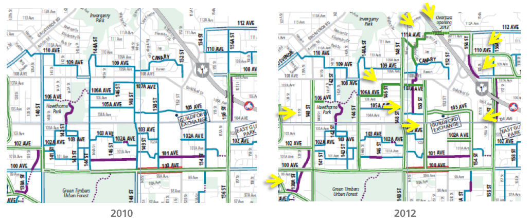
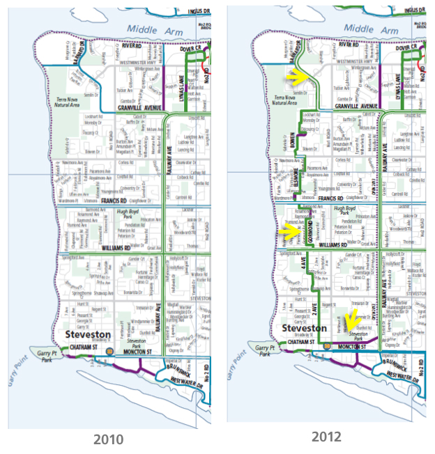
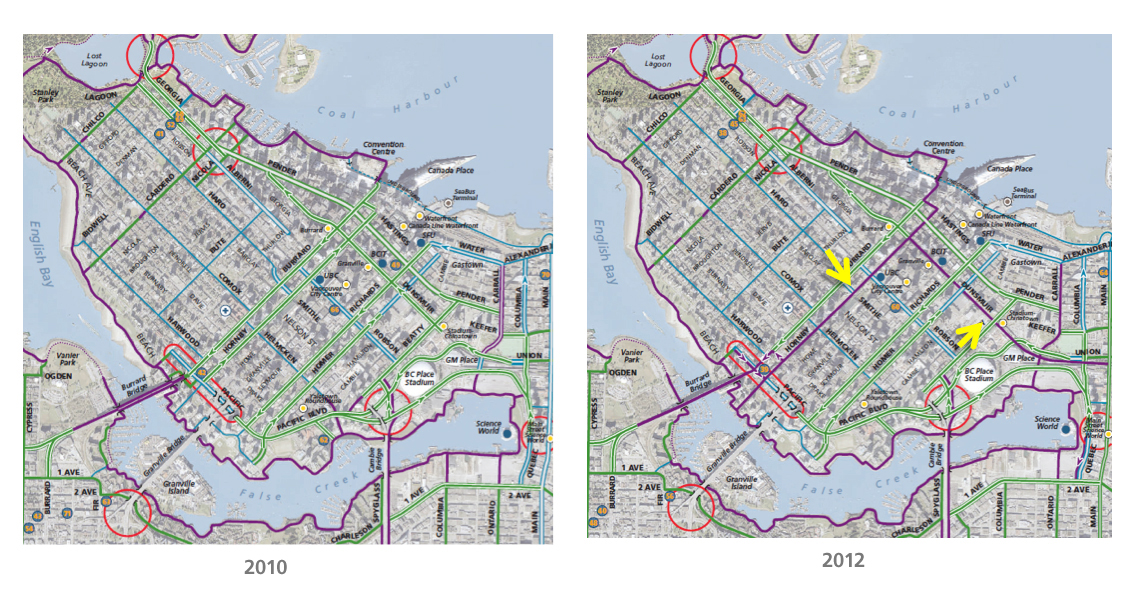
First, a bit of context. In the cycling map, any blue routes are considered “informal routes”— they’re not official bike routes, but ones that are recommended in the absence of formal bike routes. Green routes are formal bike routes officially supported by each city—for example, the City of Vancouver provides crosswalk light buttons that are easy for cyclists to reach on many of its official bike routes. So when routes change from blue to green on the map, that’s a good thing!
As well, purple routes on the map are separated from traffic and are considered the most desirable type of route, according to our research. So when new purple routes show up on the map, that’s also very good for encouraging cycling.
Our bike planning team used yellow arrows in the pictures above to highlight the differences in the 2012 map. As you can see, Surrey has converted a lot of informal bike routes in this area to formal cycling routes, and a new bike overpass where 112 Street runs into Highway 1. Hurrah!
Richmond

In Richmond, a new north-south route has been added from Barnard Drive down to Steveston. And there’s a new off-street separated bike lane through Steveston Park, parallel to Moncton Street.
Downtown Vancouver

As well, as many of you already know, there have been a number of separated bike lanes added in downtown Vancouver in the past few years. And now they are on our map!
Where to get them and more
Again, grab the map by downloading it from the Cycling Maps section of the TransLink website. Printed versions of the maps for FREE this year—just keep an eye on the Cycling Maps section for a list of locations. (Edit July 25, 2012: here is that list of locations!)
And feel free to share any questions or comments: I’ll pass them on to our cycling team for answers.


Interestingly, I got my 4th edition $4.95 map for free because the workers at the head office forgot to charge. I didn’t know it cost money until I got home; I was looking for the CVG map but they gave me that instead.
And since it was free, I’ve been taking good care of it; making sure I use care to prevent ripping. I suspect that its value will go down when it goes for free. “Who cares if it gets wet, I can get a new one anytime!”
Who is providing the Surrey map information? It’s claiming that roads such as Colebrook (e.g. King George to 152 St) and 128 St (e.g. 72 Ave to 88 Ave) are bike routes with bicycle markings.
I have never seen any bike markings on many of the routes in Surrey! I can’t recall ever seeing any bikes using these many of these so-called routes! Why? because you would be fully biking in traffic; it would be suicidal. I would liken this to biking down Oak St (south of King Edward) or SE Marine Drive in Vancouver; even hard core bikers won’t do it.
I strongly suggest that actual bikers be consulted before the next map comes out. Identifying bike routes that are clearly unsuitable for bikers does a disservice to those hoping to use it and will serve only to reflect badly on Translink.
Thanks for showing the comparison between 2010 and 2012. It’s great to see all the improvements being made.
Hi John: the map information is coordinated with staff at the municipalities to ensure accuracy. We’re checking in on the item you’ve mentioned though! I’ll let you know once there are updates.
John: here’s the clarification from staff at the City of Surrey.
Actual bikers were consulted, sort of. The Surrey, White Rock, North Delta HUB group had input into the Translink bike map. We added the single blue line routes that go on local streets or short purple lines where there are off street trails. I do not know if the rest of the local groups were consulted. We contacted Translink so we could get our input in. Next time Translink should contact all of the HUB local groups to get input instead.
Tim: sorry for the delayed response, but I did receive a response to your comment from our bike team and wanted to reply with it.