Plan your cycling trips with UBC’s online map tool
Plan your cycling trips with UBC’s online map tool

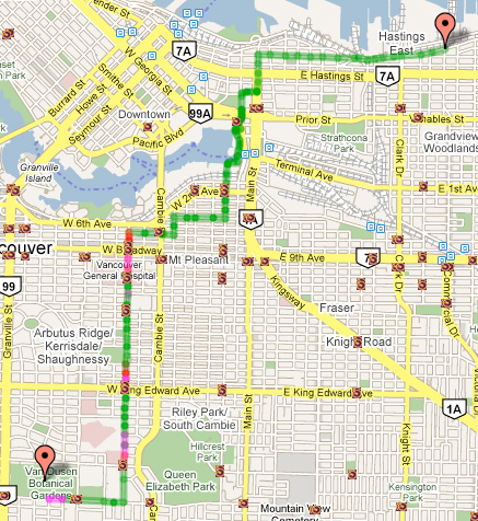
Want to bike somewhere in Metro Vancouver, but you don’t know the best route? There’s a cycling map tool from UBC that could help you out.
It’s called the cycling route planner, and it’s a project from professor Michael Brauer at UBC’s Centre for Health and Environment Research.
It uses Google Maps and has the same functionality — plug in your start and end points, and the planner design your trip using local cycling routes. (TransLink provides all the data about the cycling network, including the locations of cyclist-operated traffic signals!)
However, the cycling planner will also show how steep the hills are on your trip, whether your route has lots of greenery, how much traffic pollution and greenhouse gases you’ll prevent, and how many calories you’ll burn.

Michael explained that the route planner is part of Cycling in Cities, a larger research project investigating factors that make people want to cycle (or not), as well as examining cycling injuries and their contexts.
The planner was developed for those who want to get started with cycling. A survey conducted for the project showed novice cyclists would give biking more of a try if a web-based trip planner was available.
“Regular cyclists already know where to go, and the route planner’s not going to give you the nitty gritty details that you know from experience,” explained Michael.
The tool took a year to create, with a programmer and a geographer working on the site. So far, the route planner has been up for over a year, and gets about 100 visits a day — although the CBC ran a story on the planner last week, which brought thousands of hits to the site.
For the future, Michael says he’s interested in doing another version of the map that includes user input, with comments displayed on routes like “This side street is much faster,” or “Go over a block this way—you’ll find an amazing house.”
With the map he’s got, however, he’s made one small step to encourage more people to cycle.
“Cycling trips make up only two per cent of trips in our region, while some European cities are at 20 to 30 per cent,” Michael said. “But even if we went from two per cent to just 10 per cent, that would be huge.”


I was hoping for something like this in my younger days. I hope this technology can be to work on my Blackberry or Google Maps mobile.
The big drawback of the online planner (for cycling in North Vancouver anyways) is that the planner relies on the municipalities for supplying the bike routes instead of getting input from users. Many of North Vancouver’s official bike routes are busy roads with no bike lane, with parked cars and a green sign indicating a “bike route”. The online planner should only include real bike routes, i.e. bike lanes (indicating if they randomly end as many do), quiet residential streets, multi-use paths, etc. When I first tried the planner it sent me along a major 4-lane road in North Vancouver that has no bike lane or shoulder for bikes.
Thanks cyclist. If you haven’t already, send your feedback in to the map project. As well, I don’t know if you saw, but my post talks about how Michael is thinking of doing a user-input version of the map next — so it might be coming!
Do you know if at any point there will be a mobile version or application?
I’m not certain. I would guess it depends on demand, funding, and staffing? For a better answer, email the map project’s official email address. I’m sure they’ll have more answers for you!
[…] to Translink’s Buzzer Blog for tipping us off to this […]
[…] And if you don’t know the bike routes in your area, try out UBC’s handy cycling route planner, which I also profiled on the blog. […]
Here’s some up and coming competition from Google…
http://www.pcworld.com/article/191152/bike_directions_added_to_google_maps.html?tk=rss_main
;-):
Ooh, neat!
One more for the interesting links collection!
I’ll share that with our cycling staff too.
Blackberry users celebrate! Download Google maps 4.2 to use the cyclist feature!
Here’s the link for more information….
http://crackberry.com/blackberrys-and-biker-shorts-google-maps-get-updated-version-4-2
I appreciate for your blog post, thanks for sharing.