Canada Line pedestrian-bicycle bridge opens Friday, Aug. 14
Canada Line pedestrian-bicycle bridge opens Friday, Aug. 14


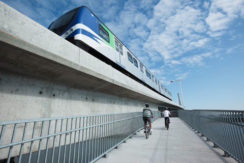
We’re opening the Canada Line Pedestrian-Bicycle Bridge on Friday Aug. 14!
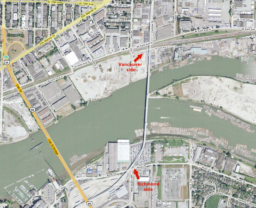
It’s a new walking/cycling bridge attached to the side of the North Arm Bridge—that’s the bridge carrying the Canada Line over the Fraser River, connecting Vancouver and Richmond.
The $10 million bridge was built and financed by TransLink, in conjunction with Canada Line. As cycling networks are developed in Richmond and Vancouver, this bridge provides a vital link between the cities!
Plus if you’re interested, there’s a small opening ceremony taking place tomorrow morning, with things kicking off at 12:30 p.m. (It’s just a ceremony: no cake or entertainment or anything!)
Parking is very limited, so please bike, walk, or take transit to the Vancouver side, and you can join us for a ceremonial first walk across the bridge.
The walk will be led by TransLink CEO Tom Prendergast and Vancouver Deputy Mayor Geoff Meggs from the north side, accompanied by police bike patrols, and meeting with Acting Mayor Ken Johnston of Richmond in the centre.
They will then carry on to the south side of the span, where a ribbon cutting ceremony will take place on the Richmond side. Once the ceremony is complete, the bridge will be opened for bicycle and pedestrian traffic! (It will be open 24 hours a day, 7 days a week, by the way.)


I probably won’t go to the ceremony, but I’ll likely mosey on down to the bridge tomorrow anyway. It’ll ease the pain on waiting for the Canada Line to open.
Nice, I’m gonna be at work, but I’ll ride it this weekend sometime!
Has the bridge not yet been opened for peds/cyclists? I know someone who rode it months ago, and they said that they saw definitely evidence of cyclists that had passed before (eg tracks in the dust).
Not sure
It’s definitely not open right now, so if anyone’s been riding across it, that is completely unofficial. There’s a locked fence up on both sides of the bridge at the moment.
Don’t know if I should go to this or not, Friday is a busy day. But… being able to walk across the North Arm with trains going back and forth sounds tempting.
Tsushima: Well, you can basically show up any time after we open it on Friday, since the bridge is open 24/7 after that. And I’ll have photos of the ceremony so it’ll be just like you were there :) I guess I’m just saying don’t worry about missing the ceremony! It’s going to be short and sweet.
The entrances to the bridge are between Bridgeport and Marine Drive stations, right? The bridge itself looks AMAZING. =D
Good to know Jhen. Is that the only walkway or is there another one on the opposite side of the train bridge?
Also, I remember you mentioning an opening ceremony for the actual Canada Line taking place on Monday. Is that a public event or a TransLink/government/media only event?
Tsushima: That’s the only walkway on the bridge. And yes, on Monday, the opening ceremony on the Canada Line is just a TransLink/govt/media event. The majority of opening day is all about the public though :)
When it says the cost of the bridge is $10 million, is that the cost of the ped/bike bridge, or the North Arm bridge?
Hopefully the bridge will be popular – the cyclist connection between Vancouver and Richmond hasn’t really existed in the past.
Kenny: $10 million is the cost of the pedestrian bridge. And I hope it’s popular too!
@kenny: Actually the Oak bridge had a major refurbishment about 10 years ago for cyclists. Prior to those tall hand rails and guard rails did not exist.
Is there a walking/cycling map of the bridge? ie where do we get on in Vancouver …north side of the Cambie/Marine intersection?
And in Richmond…south side of Van Horne/Great Canadian Way?
I’ve always wanted a walkway along the skytrain concrete structures…guess someone’s been thinking nowadays.
great idea to be away from the traffic, noise, pollution etc but what about crime/graffiti? Have these been considered? I sure hope there are cameras and emergency buttons along the route in case something happens because the bridge sounds a bit too covered for my comfort.
win-nie: No official map yet, but here’s a rough hand drawn map showing how to approach from the north side.
Plus one of our planners has kindly provided some written instructions:
The bridge route is very nice (I rode it the first day). We’re bicycling with friends today from downtown Vancouver to Steveston. While these instructions are appreciated, it’s embarrassing that there’s no proper map, showing connections to at least Cypress, Heather and Ontario on the north side, and routes through the industrial maze on the south side. I’ve spent an hour online printing various Google maps, searching Bikely and the UBC maps and bike club sites. Had this lack of wayfinding been true of the Canada Line stations, there would havve been chaos, and recriminations.
Michael:
I sent your comments on to our planning dept at TransLink (they handle cycling) and here’s some info that might help.
Basically, the Canada Line bike bridge and its connections will appear on the new editions of the City of Vancouver’s cycling map, the City of Richmond’s cycling map and TransLink’s regional cycling map. (TransLink’s regional map is due out this month, pending approvals from our municipal partners.)
Unfortunately, putting a together a map for short-term distribution has some challenges. For example, staffing for cycling programs is currently low in both the municipalities and at TransLink, leaving fewer resources to put those maps together, especially when the regional update is coming out soon.
Anyway, the regional updated map will be here soon enough, which will provide a clear outline of the connections to the bike bridge.
Thanks for coping in the meantime though!
Click on my name link to see an interactive 790 megapixel panorama of the bridge view.
Neat!
Greetings from New Zealand, where we are working hard to get a walking and cycling path on the Auckland Harbour Bridge, similar to what you’ve got here.
Can you someone help with the following questions regarding the Canada Line – Pedestrian / Bicycle bridge…
1) What’s the width of the path?
2) What’s the maximum gradient on the path?
3) How are collisions avoided, eg: between downhill cyclists and pedestrians? Is the sign: “Bump 25 metres ahead” referring to a deliberate speed bump to slow cyclists down? (See video at 54 seconds: http://www.youtube.com/watch?v=i49nxEE4Res )
Would greatly appreciate your feedback. Thanks so much… Bevan
E-mail: bevan@fast.gen.nz
Bevan: I have asked a colleague to reply to you via e-mail. Best of luck with the bridge!
[…] happy to hear that Richmond has just unveiled a brand new, $265,000 bike route, running from the bike lane on the new Canada Line Bridge, along Van Horne Way to the Bridgeport […]
Richmond has just opened a new bike route running from the Canada Line Bridge to the Bridgeport Trail – see http://averagejoecyclist.com/?p=1914
Average Joe: thanks for the info!
Neat. I will take this bike path since I’m a cyclist in Vancouver. I found another bridge retrofit in NC that had been refurbised about 8 years ago for cyclists as well. This is neat as well for all cyclist – see http://www.maadigroup.com/wp-content/uploads/2010/12/Bridge-Widening_MAADI3_V3_EN.pdf
[…] highlight of this bike ride was the new Canada Line pedestrian/bike bridge that was constructed at the same time as the Canada Line Skytrain bridge two years […]