Olympic travel tips: bike travel during the Games
Olympic travel tips: bike travel during the Games
For those who might be on our system for the first time during the Olympics, here’s a short series of tips to help you get on your way. (If you do know this stuff already, please pass it along to those who might find this useful!)
So far in the Olympic tips series: info on tickets, bike info, Park and Rides, a guide to transit staff, where to find real-time transit info online, and transit etiquette. Let me know if I should add anymore!
If you plan to ride your bike around the region during the Games, here’s some info to help you plan your journey.
Biking to Olympic events

Bike parking will be available at all the Olympic venues in Vancouver and Richmond, and at UBC.
Check the individual venue pages at vancouver2010.com to see the exact bike parking location at each venue.
In Vancouver, the City has expanded and changed some biking routes to help cyclists get around town during the Games. Visit the City’s bike routes page for details. They also have a bigger list of all bike parking locations in the city.
Richmond’s bike routes will remain unchanged for the Games. Here’s their Olympic info about route info and bike parking at their venues. And here’s their main non-Olympic cycling page for even more info.
Bikes and transit

Bikes will be permitted on SeaBus, West Coast Express, and all buses.
Unfortunately, bikes won’t be allowed on SkyTrain from Monday, February 8 to Wednesday, March 3, since rush-hour crowds are expected all day during the Olympics. (Folding bicycles that can be stored in a bag will still be permitted.)
You can still bike to a station then hop on the train, though. Bike racks are located at all SkyTrain stations, bus exchanges, and Park & Ride lots. There are also bike lockers available for monthly rental at many locations too – check the TransLink bike locker page for more info.
Plan your cycling trip

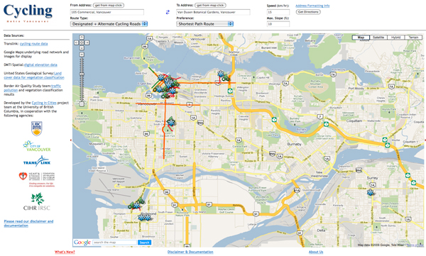
Also! You can plan your bike trip with UBC’s cycling trip planner which has now been updated with info on Olympic bike parking and reroutes. (We contributed our bike info to this site—it’s a great tool!)
We’ve also updated the regional cycling map, with information about the new bike routes built in the last several years, plus bike shop locations and more. You can find the map online—check out the “Full Maps” on our cycling page—or pick up a print copy from the Vancouver Area Cycling Coalition’s new offices at 3 West 3rd Ave in Vancouver, Mon-Fri 9:30 a.m. to 5:30 p.m. (Check our vendors too: the maps are making their way out to them.)
General winter riding tips
Check out the main cycling page on the TransLink website – it links to some great community resources, like the Vancouver Area Cycling Coalition (VACC), who you can turn to for cycling help.
The VACC has also pointed out some informative 2010 cycling posts from Biking Bis and Pedal Pundit.
Plus, last November, we were also a major sponsor of Bike to Work Week to get people ready for winter riding. I wrote some winter riding tips up for the blog: here’s one on prepping for your ride, plus five things learned from riding (plus five more lessons!), and how to care for your bike in winter.
Hope this helps — please do leave comments if you have more to add!


Will the Skytrain bike exclusion, include the Canada Line?
Yes it will.
Last year I was unable to convince even one person to bike for their commute. Few people showed interest but then I tried to explain the rules for allowing bikes on the Skytrain and I got confused myself. Attempt explaining to people they can’t take their bikes on the skytrain when commuting, but on off hours when they are sitting at home they are allowed to take their bikes to, uh, their work.
The rules are way too confusing and the bike parking is far too theft prone. The greenway opening last year was fantastic, but if we want more people to bike on longer commutes it needs to be seen as easier than driving. People need to think ‘parking my car will be a hassle, I can just jump on my bike and park safely’, not ‘I wonder if this magical hour is when I can take my bike on the skytrain and if where I need to go has safe secure parking’.
I understand somewhat the restriction during the games, but even during regular times its not made easy to bike and take the skytrain or bus.
I’m so insanely disappointed in TransLink with this “Surprise!! No Bikes on Trains!!” at the last minute. I’m not saying it wasn’t published before somewhere, but given that the CoV for instance has had their Olympic bike closures and reroutes published for well over a year it would have made sense to ensure we all could actually FIND this information in one place.
Thanks Jot. Sorry to hear the bike experience hasn’t been too great. We are one of the few systems that allows bikes on all forms of transit, but there’s certainly room for improvement.
Sorry Bryn: as far as I know, the news only came down recently, so that’s when we put it out. Not that that is much comfort at all. I still plan on biking as much as I can during the Olympics, anyway!
From my experience, the Olympics have not been good to cyclists thus far. Which is surprising, considering the planners have been encouraging people to ditch their cars and ride their bikes to avoid congestion. A lot of work has gone into creating bike parking lots, but the routes to them are dangerous.
My normal bike route takes me down Ontario, past Science World, and into downtown along Pender. Since Ontario was shut down to protect the Olympic village, cyclists have been redirected onto Quebec Street. Cars have recently been banned from Quebec, but cyclists are allowed. However, the stretch between Terminal and 2nd is treacherous – all the pedestrians and cyclists heading in both directions are being squeezed onto a tiny sidewalk. Someone is going to get hurt. The only other alternative to Quebec is taking a very crowded Main Street.
Once I get past Science World, things are looking just as bad. Pender West of Beatty is going to have an Olympic lane. So all vehicle traffic and bikes will be sharing a single lane.
I just want to point out I’m not taking a purposely dangerous route. That is the suggested route proposed by the route planners linked to above. I routinely cycle, and will continue to do so during the Olympics. But my girlfriend, who is more careful with her life isn’t even considering it.
[…] in this series: info on tickets, bike info, trip planning, where to get transit information, maybe bus etiquette. Let me know if I should add […]
There is a trend in bike comments here and other blogs about north american cycling. Generally its “my significant other thinks I’m crazy, but I try to bike everywhere. She/he won’t even consider it”. As long as biking is seen as how the crazy people get around, and not the de facto healthy safe way to get around it will never, ever take off in a meaningful way.
Thanks for the response Jhenifer, and thanks a lot for this blog. Translink is fantastic in my opinion, but like you said we can do better. We are not at the tipping point yet where biking is seen as safe or even normal. Imagine if Translink decided cars couldn’t drive on the road during rush hour, you are telling the same thing to bicyclists.
The maps on the translink website have not been updated yet. No Golden Ears bridge, no Canada Line, no CVG
Tim: Hmm… I’ve just looked. It’s the “Full Maps” that are most recently updated — the individual maps still seem to be older. So please refer to the big regional maps for the latest info!
[…] in this series: info on tickets, bike info, trip planning, where to get transit information, maybe bus etiquette. Let me know if I should add […]
Not allowing bikes on Skytrain is a really negative step. What if the train is not full? The message is: Welcome to Vancouver where we are not really serious about greener alternatives.
I just found out that Cambie will be closed for a few days. I come from Davie/Robson down to Main/5th ish..I thought I had it all planned out to go via Pacific/Cambie Bridge/2nd/Quebec/work. What route am I missing that would take me here without getting eaten by a car/bus/ or angry tourist/resident?? I would like a quick route, biking 1 hr for a 15 minute ride won’t sit well..I will take anyones advice. I also have no sense of direction and get lost (even in Vancouver) easily so I am a little concerned about this recent tidbit. I did all my pre Olympic planning so I wouldn’t have a panic attack. =(
If your at Robson, I would head North to Pender to go East and then South on Main. The #19 Metrotown/Stanley Park would be perfect.
Otherwise across the Burrard/Granville bridge to join your 4th Ave route by car.
I could go down Robson..but I am sure it will be a mess, generally is on non Olympic days. I live more on the Beach side so I guess it’s the Burrard Bridge and crossing/riding over. Are there bike routes on Fourth?? I seem to remember LOTS of buses going down Fourth… Tell me again why we’ve closed off Cambie?? Who really is going to the Opening and Closing YawnFests anyways?? Parents. That’s who. I can’t believe they have made it a royal pain for bikers as well. =( I wouldn’t ride Transit for a million during the Olympics…and I sure the hell wouldn’t want to be a Transit Driver then either..I hope they have security on major bus routes..I see angry people in our future. So there is no mystery route I am missing??? I thought the seawall..but then you hit the Red Zones…I have no idea why I can ride through the Pedestrian Zones. =( Boo!
Fourth Avenue does not have a bike route, but 7th Avenue does and it’s just two blocks South of your work sight. Cypress also has a bike route just one block West of Burrard. Another bike route option is Pender, which does have a bike lane.
I don’t know when you work, but Robson will be a pedestrian mall between noon and midnight each day between Bute and Beatty. Many have long requested festivals and car free zones in various neighbourhoods, especially downtown. The Olympics will be one of the biggest opportunties to car-free celebrations for Vancouver.
To clarify Cambie is not closed off, only the curb lanes for buses and Olympic vehicles.
The Cambie bridge is closed to cars noon to midnight for the two opening and closing ceremonies (4 afternoons and evenings), but pedestrians and cyclists are not affected by the closure.
BTW… these links may be of interest…
http://www.ctvbc.ctv.ca/servlet/an/local/CTVNews/20100112/bc_olympics_traffic_plan_100112/20100112?hub=BritishColumbiaHome
http://www.metronews.ca/vancouver/local/article/420856–cambie-street-bridge-to-close-for-olympic-ceremonies-rehearsal
http://olympichostcity.vancouver.ca/pdf/Olympic%20route%20network%20maps.pdf
If you find Robson congestion too heavy, you will also have an option to ZipTrek above the crowds for 170 meters of your commute.
“If you find Robson congestion too heavy, you will also have an option to ZipTrek above the crowds for 170 meters of your commute.”
EEP!! I’ll pass..LOL
So the bike lanes are still open? ok well that’s awesome then. I was panicking because I was told it wasn’t! That makes more sense! I will just have to put hockey sticks like moose atlers on my bike to move people along on the shared bike/ped path on Cambie!!
So, if it’s a red zone..that means no bikes even right?? So no biking by GM Place to Quebec to work right?? That would be nice if they let me..LMAO. What happens if I wear my Wickenheiser jersey?? Maybe they will let me in..
Bike lanes through the village are closed for security and operations. However adjacent bike lanes on 7th, Cypress and Pender are good alternatives to get to your destination with minimal delays.
[…] far in the Olympic tips series: info on tickets, bike info, Park and Rides, bus etiquette. Let me know if I should add anymore! This lady is checking for […]
[…] far in the Olympic tips series: info on tickets, bike info, Park and Rides, bus etiquette. Let me know if I should add […]
[…] far in the Olympic tips series: info on tickets, bike info, Park and Rides, a guide to transit staff, where to find real-time transit info online, and transit […]
I was trying to do my part in minimising vehicular traffic during the Olympics but new rules seemed to have put a stop to that. I used to board the Canadaline at 0500, get off at Broadway, bike to work (downtown) and at the end of the day bike all the way home (25km). Now because of the no bike rule, I have to drive part way find parking in an area not affected by the Olympics and bike from there. Why can people not bring a bike on say between 0500 and 0630? Is there going to be that many people at that time of the morning? Now if I want to ride, I have to deal with all of the unsafe bike routes from Richmond to downtown. By unsafe, I mean restrictions on some routes and increased traffic on others because all of the main roads are closed or restricted. For a supposed Green city, government sure works hard at deterring people from using transit.
i hate the olympics could we not talk about it anymore its anoying me
Sorry jack: everyone at TransLink is heavily focused on Olympic work until the start of March, so it’s hard not to talk about it!
rj: I’m sorry about the bike restrictions! Essentially rush hour levels are expected almost all day and in all directions during the Olympics, especially as people are asked to come to venues early for their events, and owing to celebration sites being open daily. (Some events have 9 or 10 a.m. starts, and people are being asked to come early to get through security.) I know it’s not much comfort, but hopefully we can all hang on until March!
Yes a friend last Saturday took 90 minutes to get from Stanley Park to Science World. Avoid travelling with your car in the area for the next few weeks.
Pender Street is shown as a bike route on the olympics biking link, but is shown on the ubc route planner as Olympic Lane no bikes permitted. This is my eastbound route daily, and I’ve been riding in the Olympics lane as the other lane is a parking lot of congestion. Am I going to get ticketed for this? What did the planners intend when they showed Pender as a bike route??
ck:
Olympic lanes and the bike strategy for Vancouver are actually the domain of the City of Vancouver, so you should hit them up to get exact answers to your questions.
In the meanwhile though, the road closures map from the City shows that Pender is only an Olympic Lane from Cambie St to Howe St downtown. If your route doesn’t include that section, you’re OK. It’s not the entirety of Pender Street.
Also, I would consider the road closures map I just linked to as a more credible authority than the UBC route planner, since it’s linked to on travelsmart2010.ca and all our partners have been pointing to it as the chief source for road closures info.
The city of Vancouver map clearly shows Pender as a bike route. I guess Cordova is the only route available eastbound from west of Howe.
http://olympichostcity.vancouver.ca/pdf/Host%20City%20bike%20network.pdf
Hmmm… confusing! I was just discussing this with a colleague, and they have posited that perhaps the other lanes on Pender are the recommended bike routes. (Olympic lanes are only the curb lanes.) Let me see if I can reach someone at the City of Vancouver to clarify.
Aha, the City has pointed me to the answer!
Here’s the Pender bike lane reroute info:
I have a folding bike. Am I right to assume that so long as I have it folded in a bag/cover that there are no Skytrain/Canada Line restrictions for it, including during the Olympics? Gee, I hope all the transit operators on the front lines are aware of this.
ECruz:
Folding bikes in a bag are permitted on all SkyTrain lines. There’s a note in the blog post about it plus it’s in the press release we sent out to media. Buses and SeaBus and West Coast Express don’t have any changes to their bike policies however, so you are fine to take the bike on those modes of travel.
I was looking for London Olympic travel advice to build upon the information found on the get ahead of the games site and found your blog really interesting and relevant considering the availably of the Boris Bikes in London. I wish there was a London 2012 equivalent of this blog!