
Mapping your bike route and the “slow” streets movement
Mapping your bike route and the “slow” streets movement

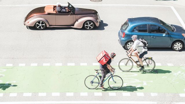
While transit ridership is down in most cities around the globe you might have noticed more people out walking, cycling and breathing in the fresh air!
In the latest in our series to support HUB Cycling’s Go By Bike Week, we take a look some of the changes to streets happening locally and around the world, as well as some trip planning tools and recommended routes to make sure you can get around Metro Vancouver actively and safely.
Is it me or have I been seeing lots of people out walking and cycling?
It’s not just you! While active commuting trips and commuting trips of all types have decreased during the pandemic, recreational cycling trips are up significantly in cities like Vancouver (an 85 per cent increase during March).
Similar increases have been seen across the globe — in Beijing, New York and London — as people look to stay active, commute to work were needed, and take important mental health and physical activity breaks.
Parks in B.C. have witnessed a 62 per cent increase in visitations in May while in the Lower Mainland, Metro Vancouver parks are seeing similar activity with a 67 per cent increase to the end of April 2020.
What’s happening to streets around Metro Vancouver and the globe?
Now you might have been hearing terms like “COVID streets,” “summer streets” or “slow streets.” Local, federal and global physical distancing regulations have sparked conversation around reallocating more road, park and sidewalk space for people to walk, cycle, roll, sit and queue safely. With traffic decreasing during the pandemic, that’s meant cities around the world have moved to turn car lanes into active transportation lanes.
Cities such as Vancouver (50km of slow streets), Oakland, California (119km of slow streets), Portland, Oregon (slow/safe streets at 160 locations), Milan (35km of Strade Aperte [open roads]) and Paris (50km converted bike streets and 30 pedestrianized streets) have reacted rapidly to re-allocate space for cars, to people.
Locally, the City of Vancouver has launched its Room to Move, Room to Queue and Room to Load initiative, installing new routes that prioritize walking, cycling and rolling to make it easier for people to exercise and access businesses in their local neighbourhood.
The city has closed the eastbound lanes on Beach Avenue to all vehicles from Stanley Park to Hornby Street, as well as closing Stanley Park to all vehicles (excluding the Stanley Park Causeway/Highway 99).
To find out more about these developing changes visit the city’s temporary road closures and changes during COVID-19 page, have a read of their FAQs on Slow Streets, or email the city directly: slowstreets@vancouver.ca
What are some things to keep in mind when planning my bike trip?
TransLink recommends using routes with dedicated cycling infrastructure separated from motor vehicles, such as bike lanes, as much as possible. To map out your cycling route, there are a few tools we recommend.
1. Visit TransLink’s Cycling Maps page to view several major TransLink-funded cycleways running parallel to SkyTrain routes.
- Canada Line: Arbutus Greenway
- Expo Line: BC Parkway
- Millennium Line: Central Valley Greenway
- Downtown Vancouver: Sea Wall, Adanac Avenue-Union St, 10th Ave, and Dunsmuir bikeways
2. Use Google Maps for trip planning and the estimated time it will take you, but please be mindful, particularly beginner cyclists, that Google Maps does not always recommend the safest cycling routes or take new and existing protected infrastructure into account. If you want to make sure you’re accessing cycling routes for all ages and abilities, please check out these other trip planning platforms:
3. Vancouver Bike Route Planner allows you to filter for “bike routes” and “safer” bike routes as well as a full list of SkyTrain stations, Mobi Bike Share stations and elevation gains.
4. Bikemaps.org is a useful mapping tool that also allows you to filter through new cycling infrastructure, collisions reports, hazards and bike thefts.
5. Bike Citizens Vancouver Did you know that nearly half of all trips under 5 km in Metro Vancouver are made by car? Many of these trips for groceries, prescriptions, and other essentials can easily be done by bicycle. In fact, running errands by bike for trips of this distance is often faster and more convenient than driving. Bicycles are one of the most efficient forms of transport so if you want to SEE how far you can go on a city bike, road bike or mountain bike over 5, 10, 15, and 30-minute increments, check out this handy mapping tool. You might be surprised!
What are other cities in Metro Vancouver doing to open streets?
For a full list of temporary streets changes during COVID please visit your municipality’s website for the most recent updates. In the meantime, here are a few that have been confirmed in the Lower Mainland:
New Westminster
- McInnes Overpass – Closed the northbound vehicle lane to vehicles, opening it to pedestrians and cyclists.
- Sixth Avenue – reallocated some curbside parking spaces on Sixth Street (near Sixth Avenue) to a place where pedestrians can wait for the traffic lights to change and pass one another on the sidewalk.
- Central Valley GW – Closing a southbound curb lane on East Columbia Street / North Rd north of Hume Park to motor vehicles to improve conditions for people walking and cycling along the Central Valley Greenway.
City of North Vancouver
- Grand Boulevard – Converted road space west between Keith and 19th and Grand Boulevard between 19th and 23rd (these routes are also appropriate for commuting traffic to and from Lynn valley to central Lonsdale).
- Proposed – All local neighbourhood routes with low traffic volumes (St Andrews, 17th, 4th, 27th and Sutherland)
- Esplanade, Lonsdale with focus at the intersections of 13th, 15th, 17th streets.
- Existing bike routes that do not facilitate passing with physical distance without taking the vehicle travel lane: 3rd and 15th streets, 1st/2nd Street west of 3rd, East and West Keith, 13th Street.
Maple Ridge
- Proposed
- 123 St Avenue between 203 St to Laity St
- 227 St between Brown Avenue and Abernethy Way
Port Moody
- Recommended Routes
- Neighbourhood bike routes: George Street, Glenayre Drive, Glencoe Drive, Ailsa Drive, College Park Way, Washington, Princeton Ave, Harvard Drive, as well as the Shoreline Trail (some portions are one way only).
Richmond
- Bayview Street – Established temporary walkway in Steveston Village along the south side of (No. 1 Road-Third Avenue) that provides additional space for safe distancing.
- Garry Point Park – Implemented one-way walking routes in Garry Point Park in
- Other recommended routes – Railway Greenway, Railway Ave (Granville Ave-Moncton St), Crabapple Ridge Neighbourhood Bike Route, Granville Ave (Railway Ave-Garden City Road), Parkside Neighbourhood Bike Route, Shell Road Trail (Hwy 99 Overpass-Steveston Hwy)
- Perimeter Dyke Trails: South Dyke, West Dyke, Middle Arm
Surrey
- Proposed
- Surrey reports a 40% decrease in traffic volumes and is exploring 7-8 ‘recreational’ cycling routes around the city to connect to civic facilities, parks and close roads around parks to create loops.
UBC
- Proposed
- North West Marine Drive
City of Vancouver
- Stanley Park – close to cars (some exceptions apply)
- Beach Avenue – Eastbound lane closed to vehicles on Beach Ave (including Park Lane) from Stanley Park to Hornby St.
- From May 22, Vancouver is added a further 12km of Slow Streets. Visit the website for more information.
Author: James Ranson